A correct chart of the Bay of Biscay, Part of the Western...


 Cartografía
A correct chart of the Bay of Biscay, Part of the Western Ocean & Mediterranean Sea : describing the Coasts of Spain... (s.a.)
- Tindal, Nicholas, (1687-1774
Cartografía
A correct chart of the Bay of Biscay, Part of the Western Ocean & Mediterranean Sea : describing the Coasts of Spain... (s.a.)
- Tindal, Nicholas, (1687-1774
Sección: Cartografía
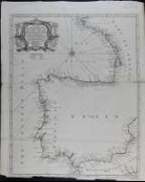
Título: A correct chart of the Bay of Biscay, Part of the Western Ocean & Mediterranean Sea : describing the Coasts of Spain and Portugal, with Part of France, From Morlaix to Valencia. Done from the latest & best Discoveries / For Mr. Tindal's Continuation of Mr. Rapin's History ; R. W. Seale del. et sculp.
Autor: Tindal, Nicholas, (1687-1774
Área de datos: [Escala indeterminada]
Publicación: [S.l.] : [s.n.], [s.a.]
Descripción física: 1 carta náutica : gravados en cobre ; 48 x 38 cm
Tipo de contenido: Imaxe (cartográfica; fixa; bidimensional; visual)
Tipo de medio: sen mediación
Notas: Tít. en cartela
Reproducción electrónica. Santiago de Compostela : Biblioteca de Galicia, 2009
Lonxitude referida ó meridiano de Londres. Marxes graduadas. Orientado con rosa con lis. Toponimia localizada nas costas. Relevo por sombreado
R.W. Seale traballou para Tindal entre 1744 e 1750 (Tooley's Dictionary of Mapmakers, 1979)
Otros autores: Rapin de Thoyras, Paul, (1661-1724
Seale, Richard William, grav.
Tipo de publicación:
Mapas
Derechos:


Xunta de Galicia. Información mantenida y publicada en internet por la Xunta de Galicia
Atención a la ciudadanía - Accesibilidad - Aviso legal - Mapa del portal